 |
| Buffalo Statue, outside Visitor Center of Antelope Island |
We are standing here just outside the Visitor Center of a "barren" island in the Great Salt Lake. By "We" I mean our little
hiking group of 8, which just the day before, on October 18, had arrived in Salt Lake City, Utah, after an arduous 15-hour trip from Stockholm.
The Island, called
Antelope Island, lies South of
Ogden, the former great center of the Pacific Railroad. It is connected to the broad stretch of land extending below the
Wasatch Range by a road bank, which can be glanced in the picture. As the road approaches the lake from the Northeast, the land turns gradually into marches and mud flats, until the mud turns into the salty lake water.
Why the buffalo on an island that appears to be burned and dry, embedded as it is in salty water? In fact, the island is rather fecund, but we did not see this in October, when most of the flowers had finished blooming and the grass dried out. We are standing at an altitude of some 1200 meters, with the island tops rising up to 2000. It rains regularly and there is snow in wintertime. There are many springs and even wetlands, warranting a rich bird life as well as roaming areas for more substantial critters.
 |
| Lonely Buffalo near Bridger Bay |
This brings us to the buffalo: the island, as a state park, happens to harbor the greatest herd of buffaloes in the world. This does not say much, since this wild oxen is almost extinct, but we should be glad for what little remains. We had high hopes of locating a substantive collection of these beasts, dreaming of stimulating them into a stampede, for photographic purposes only, of course ;-) But it turned out that they chose the Southern part of the island for grazing that very day, so only one or two outliers could be glanced along the driveway to our hiking loop.
But isn't the island called Antelope Island? What about those gracile mammals? "Yes, indeed!", you can find them here as well. They are called Pronghorn Antelopes. Unfortunately, they kept completely hidden from us that day, no doubt because there was a huge Running Event taking place on the island concurrent with our visit, so the wild ones wisely kept to the calmer areas in the South, away from the hooting, puffing and sweating crowd encroaching on their stamping grounds. But I should not exaggerate; the island is large and the crowd appeared quit thinned out in the great expanse.
 |
| Panorama, looking Northwest from White Rock Loop Trail |
To emphasize this point, take a look at the Panorama. Please double-click on it to increase its size (I hope your screen is wide enough to get it all in!). To the left, you can see White Rock Bay and, behind it, Buffalo Peak. Far off on the upper right the Wasatch Range is beckoning, colored mauve due to the great distance. Now take a look at the plain, just below where the Wasatch Range begins to taper off towards the right. Here you see a collection of small black objects, fronted by a white flap. This was the start and finish of the Great Run and also the start for our hike, the latter taking about 14 kilometers. Even if that seems a lot, the panorama you are glancing at is representing only 1/10 of the island's area; and even if our hike along the so called White Rock Loop ranged southward from here, we barely saw 1/4 of the island. So a lot of room for the wild ones to hide in and avoid contact with us!
But back to the antelopes! Even if I did not manage to get them into the camera this time, I was more lucky (that is, young enough to handle my camera with speed) in 1980. Back then, we were approaching the US Southwest from New Mexico, spending an afternoon and evening in the romantic area of
Petrified Forest. In those days, if you were lucky, you could still have a whole National Park for yourself. It had rained heavily earlier that day and was just clearing up when we arrived, so we had a great time taking in the splendor of that monument. Suddenly, when turning around, I saw two animals rushing up a slope (to get away from us, no doubt!). Up with the camera and "Click!" with the finger, and the result is now here for you to behold:
 |
| Pronghorns in Petrified Forest National Park |
Interestingly, those critters don't look like antelopes to me. With heavy body and spindly legs, they appear more like oversized goats, don't you agree? In fact, the Pronghorns are not related to antelopes at all, they form their own species, being the only surviving member of the
antilocapridae family. And they feature proudly on top of the list of fast running species. They are the frontrunners in America (with a top speed of more than 100 km/hour) and the second best in the world (after the Gepards).
There is no lack of wild species on the island. Coyote is of course prevalent here, and mule deer and bighorn sheep can been found as well. Bobcats roam the nights, but you may never see one and, in any case, you may not wish to come too close. Lesser mammals like badger, porcupine and jackrabbit, as well as rodents such as ground squirrel may cross your path on the hiking tour.
How come that there is a large island in the Salt Lake, with tops rising up to 1000 meters above the level of the lake, in the middle of a wide area that is essentially flat, covered by brine and salt planes? I am glad you ask, since the geology of the area west of the Wasatch Range, stretching across Utah and Nevada, is rather interesting. The area is called the
Great Basin, essentially a sink, more than 2000 meters below the bordering mountain ranges, the Wasatch Range on the eastside and the Sierra Nevada – bordering California – on the westside. The denomination of "sink" is very appropriate, since all rivers running into the area lose themselves and eventually evaporate.
This enormous sink, of a size a bit larger than Sweden, is essentially a desolate desert, broken up by a series of north-south oriented mountain ranges – most of them arid and barren as well, except on high. Where mountains are absent, it stretches out essentially flat, with a salty crust covering the shallow valley bottoms. You may not wish for your car to break down, if venturing out far on one of the rare sidetracks to the main routes. Without mobile phone, you will face certain death as soon as your water is running out.
 |
| Into the Great Basin – north-south mountain range in the background |
How was this great sink created? We have to thank the movement of the tectonic plates for it. Usually, those plates are grating into, or colliding with, each other. Wherever there is a collision, we can experience harsh mountain ranges, such as the Alps and the Himalaya Range. However, the great decline against the basin of the Rocky Mountain outlier (the Wasatch Range) here in Utah was actually formed by an opposite form of tectonic movements, and so were the great mountain inclines to the West of the sink.
Think of a giant rectangular wedding cake, placed on two tables put together so as to form a unified support. Now move those two tables slowly apart and watch what happens: eventually, the middle part of the cake will start to crumble and crinkle, sizable parts of it falling down in one piece, others clinging on a little while longer. Those later ones will also fall at a later stage and partly align on top of the earlier pieces. As you look at the lower support area, where all the pieces will have ultimately landed, there will be pieces of cake lying level with the support, interspersed with slanting pieces representing elevations above the support. The latter will mostly be aligned some 90 degrees against the disruptive movements. Remains of the cake will stay on top of each table, their ends rather abruptly broken off. Standing on the new lower level looking upwards, those brake-offs at the table ends will look like large mountain ranges to you, rising high above the smaller ranges placed on the lower support.
 |
| Wasatch Range, seen from Visitor Center |
It took geologists a great many years to understand, how the Great Basin was created. The hypothesis crudely explained above emerged first after the War. But it seems very plausible to me. Very precise measurements have shown, that the Eastern and Western fringes of the Basin continue to move away from each other at a pace of 2-3 cm per year. This is adding up over the year millions! What causes this movement? The most recent theory is that an earlier pacific ocean plate had been forced under the American continental plate and broken up underneath the latter plate approximately where the Great Basin is located. This meant that the Great Basin part of the American Plate is located, without an intermediate shield, directly above Earth' superheated magma. As a result it is thinning out and expanding, not unlike a copper plate, being heated from underneath by a blow torch. Fascinating, isn't it?
But let's move on to more mundane things! After all, we have a hike to report about. As already said, our walk was some 14 kilometers long and ran along a loop in the North, called
White Rock Loop Trail. The nice thing about this trail is that it is easy-going. No doubt, our travel guide used it as a warm-up for future challenges. But, even if the terrain is not very demanding, it has a lot of unusual features to show for it, as well as unexpected encounters. The latter did not involve wild animals to any degree, but rather the runners mentioned earlier, as well as the odd man or two on horseback. For riders, this island must be ideal, you can roam freely over hills and dales and feel like a true Westerner, pretending to be a buffalo hunter, like in olden days!
 |
| "Buffalo hunter" on White Rook Loop |
Even if the trail essentially goes along hill flanks without really mounting any tops, there IS the possibility of doing so by a small deviation from the beaten tracks. The top in question you can climb is called Beacon Knob (the name says it all, no huge promontory there!). Even if not a great challenge to us mountain climbers, it offers an enticing view of the Lake, the valley beyond and, farther out, one of those North-South leaning mountains adorning the Basin.
 |
| Standing on Beacon Knob |
I am well aware that some of the readers of this blog are experts in botany. To my regret, I have not a lot of flowers to show for it this time. The walking pace induced by our guide Ingemar (he is standing to the right on the above picture) did not generally permit me to take in and photograph flowers at my usual leisurely pace. But this is understandable; if you are with a group, there are deadlines to observe and group interests to take into account. Furthermore, since the other members were younger and more vigorous than me, there was rarely the option of making up for my leisurely hobby by running, once the deed was done, after a company of hikers rashly disappearing from view.
Not that there were many flowers to take in, after all. Due to the late season, there were mostly barren stalks adorning our route. But here and there, some of the lovely petals remained, usually yellow in color. Here is an example for you. I have to admit that I am not familiar with this special flower.
 |
| Last flower on barren stalk |
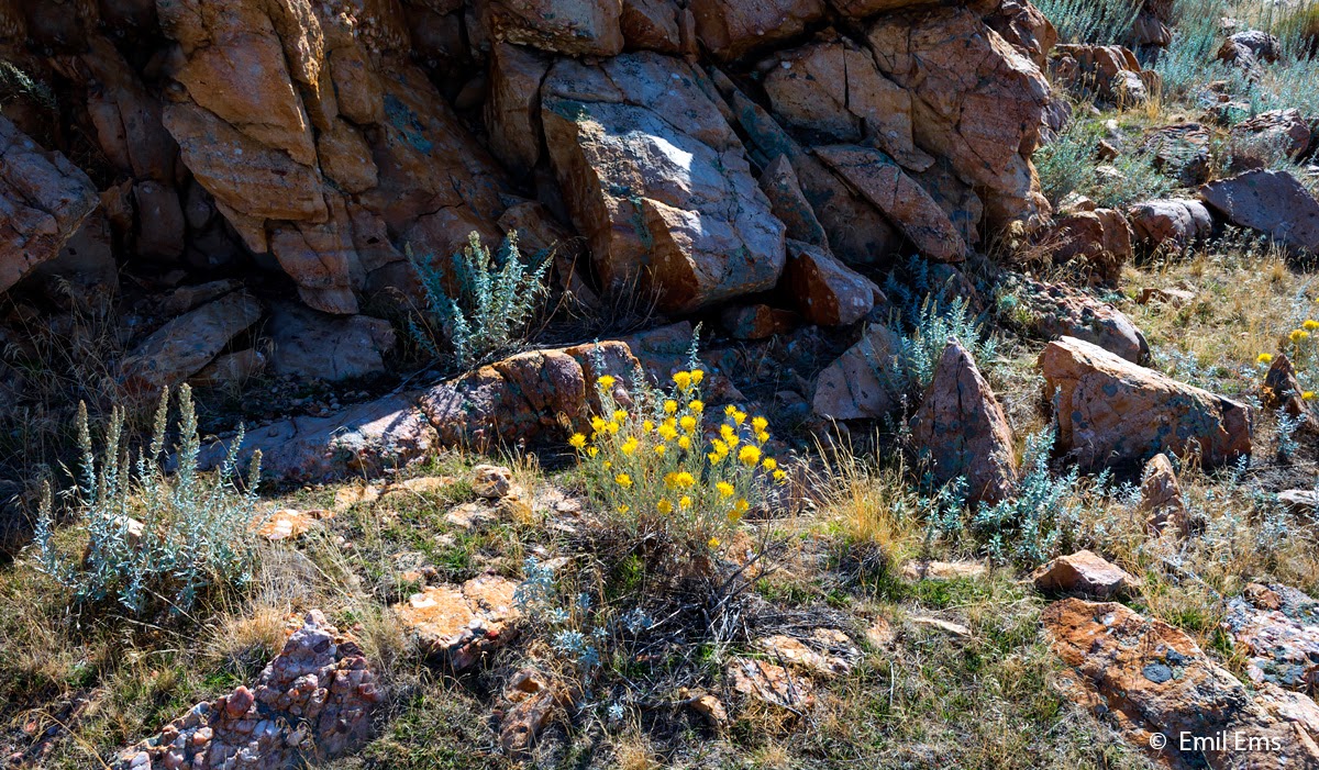
Even so, there were places, behind shadowing cliff formations, where alpine type vegetation seemed to thrive. So let us finish this blog post on a positive note, observing that also in the cold and dry season, flora seems to thrive and survive, granted that it can find a suitable niche to do so.
 |
| Flowers and shrubs sheltered by rock |


2 comments:
Dear Emil,
As always it's extremely rewarding to read your things, both because they are interesting and because of your wonderful grasp of the English language. How many memorable formulations! But by now I'm getting tired of saying this, so down to facts. You call your story "Where antelopes roam", and I think I know where you got the title from. After all, you know very, very much, not least about Americana.
What I refer to (as you well know) is the Wild West song "Home on the Range". It begins like this: Oh, give me a home, where the buffaloes roam and the deer and the antelopes play. I am sure you know it by heart, and sing it by yourself now and then. (I do that.) But there is more to it, which you probably know. When Franklin Roosevelt was first time elected president, a group of people assembled on the doorsteps of his home and sang it. But probably it wasn't because of the movements of the buffaloes and the antelopes. It was rather because of the rest of the song: Oh, give me a home, where seldom is heard is a discouraging word, and the clouds are not cloudy all day ... where the bright diamond sand flows leisurely down by the stream ... where the air is so pure, the breezes so balmy and light ... etc., etc. FDR gave them that, or nearly so. Sorry for this detour.
How nice to see you back again as commentator on this blog, Lars! Your fruitful insights are always very welcome.
I have to admit that I confused buffaloes with antelopes, when writing the title of the e-mail announcing this post. Must have been a subconscious substitution, following the fact that the island in question is called Antelope Island.
But this gave us the opportunity to learn about the rest of the song and its history, thanks to you!
Emil
Post a Comment